Resource
Reshaping Service Experience in 2025 [eBook]
1 min read
5 min read
Emergency services need to log awkward locations, such as the middle of a remote field or a mountain top, in an accurate, timely, and human-friendly manner. This can be challenging as existing methods for tracking location, such as postcodes, simply don't offer the data quality needed. As these services operate in a time-critical manner, loss of accuracy can have serious consequences.
This type of problem is not unique to emergency services. Utility companies, delivery services, and local authorities all need accurate location data which is not always achievable via postcodes.
Postcode lookup solutions are limited by the frequency that the postcode database is refreshed. New properties and awkward locations fall through the cracks. Even with a well-maintained postcode database, there will always be locations which aren't well represented by a postcode.
Latitude and longitude coordinates can help here, but entering two 8-10 digit numbers is straining on the user and prone to data entry errors. Adding complexity, there are several ways of interpreting latitude and longitude which can throw the location off. For an emergency service, even a small deviation in location could cost lives.
How can we achieve accurate location logging data in a pleasing to use and reliable manner?
Step in what3words and Oracle B2C Service, Customer Portal!
What3words is a geocoding system which assigns a unique, simple to read, 3-word phrase to every 3 metre square in the world. For example, the location of the empty fourth plinth in Trafalgar Square is represented by the phrase: "tops.such.valley". Using this approach, what3words can give extremely accurate location information, much better than postcodes, which is not as open to interpretation and easier to remember than latitude longitude coordinates.

As readers of this blog will likely know, Oracle B2C Service is a service automation solution within Oracle’s wider CX suite. It allows customers to raise enquiries and issues, known as Incidents in B2C Service terminology, to an organisation through multiple channels. One of these channels is a web self-service module called the Customer Portal.
The Customer Portal allows users to submit Incidents to the B2C Service CRM. When submitted, these can be read in B2C Service and attended to by agents.
We at Boxfusion Consulting have recently produced a solution which integrates what3words and Google Maps into the Customer Portal. This solution allows end-users to use a well-known maps interface to select a location, when raising an enquiry or issue. The what3words phrase is presented for the user to review and is submitted with the Incident.
To give as much information as possible; the latitude and longitude, as well as an approximate postcode and address, are also generated and submitted alongside the Incident. This gives the agents a fallback option in case they need to transfer information to a system which does not accept a what3words phrase.
How does this solution work? Let's take a quick tour…

Using the interface in the video above users can select a location on the familiar Google Maps interface by clicking on the map. Once a click has been registered, a location flag is added to the map and the what3words phrase linked to that location is presented to the user. The user will then enter any remaining information and submit the form. This will result in the creation of an Incident within Oracle B2C Service, which will include the what3words phrase, latitude and longitude, and approximate postcode.
In the backend, once a click is performed the Google Maps geo-caching service is called to convert the clicked location to latitude and longitude co-ordinates, as well as an approximate postcode and address. The latitude and longitude are then passed to the what3words API, which converts these into the what3words phrase for the square meter clicked.
To accommodate users who are familiar with the what3words system, such as emergency services or delivery drivers, the process can also work in reverse, with no additional customisation. Implementing this process alongside the map-click process allows users familiar with what3words to enter data in their preferred format, without impeding users who are not familiar with what3words.
The user can enter a what3words phrase into the what3word search box, which will lead to the location information being called from the Google Maps and what3words APIs. The Google Maps interface will centre on the location linked to the what3words phrase, to provide assurance to the user that the location matches the entered what3words phrase.
This is demonstrated below:
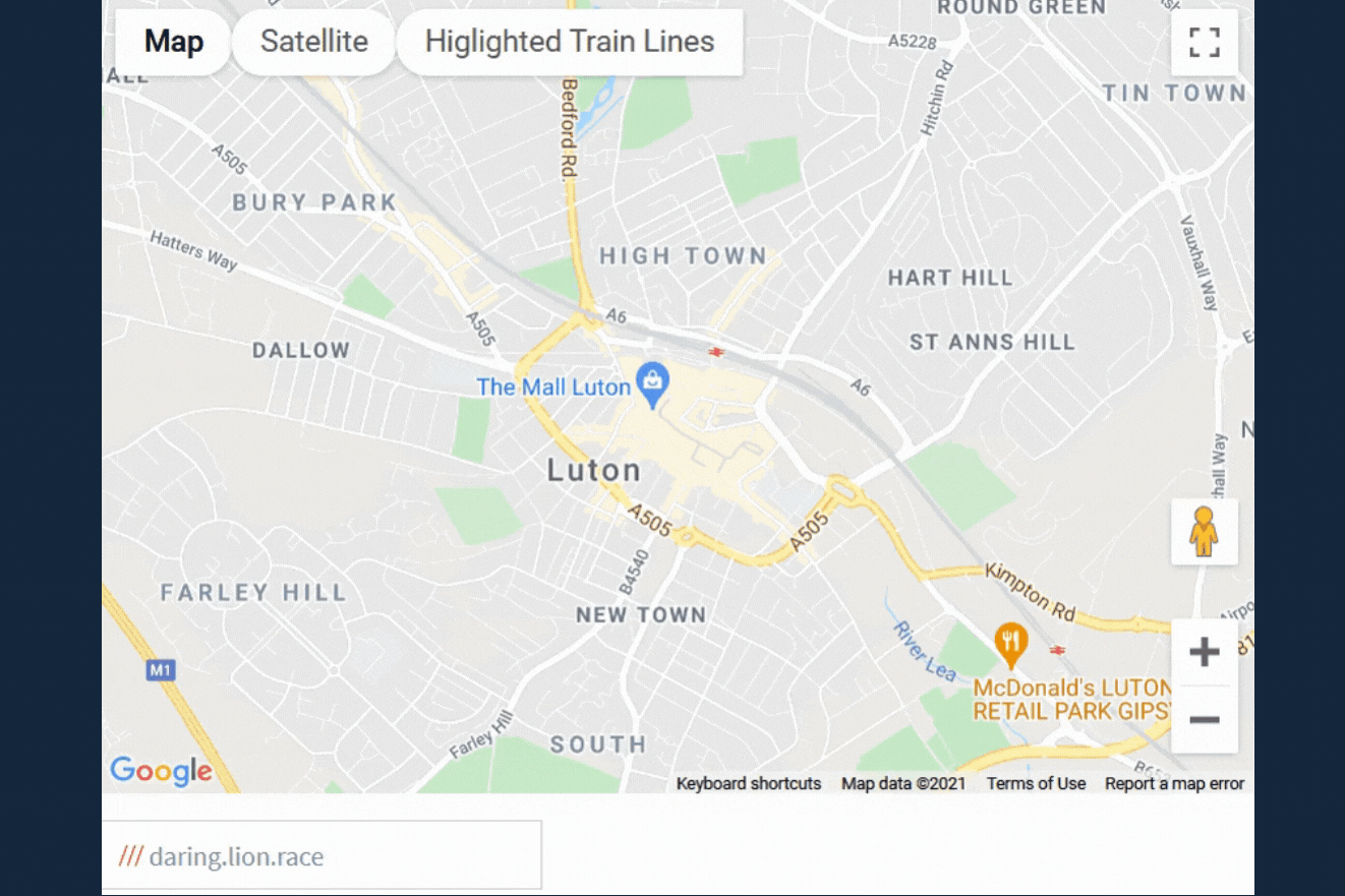
The Google Maps interface can be configured to highlight certain landmarks and features depending on the use case. For example, in the case of a rail provider that allows members of the public to raise issues relating to railway lines, the interface can be set up so that railway lines are easy to see. They can be highlighted in a high contrast colour to give the user a view of the most likely locations they would need to log an Incident against.
This feature is relatively quick to set up and is shown in the video below:

Through this quick overview of the what3words, Google Maps, and Oracle B2C Service integration we’ve seen that through a lightweight customisation we can reduce the uncertainty around logging unusual locations in an intuitive to use manner. With this interface on a utilities company or delivery service website, users will be able to accurately log awkward locations with ease.
The solution outlined above is contained within a custom widget that can be easily transferred across Oracle B2C Service Customer Portals with relatively little effort.
If your business deals with location logging and requires an accurate and user-friendly way to enter this information into an Oracle CRM solution, or if you’re curious to see how much further we can push the customisation examples above, don’t hesitate to reach out to us here at Boxfusion Consulting.
Our latest eBook explores how we've helped clients unlock the potential of AI and the latest customer service automation tools to drive real impact. It highlights where these technologies can enhance service delivery, boost efficiency, and elevate customer satisfaction.
1 min read
Explore how Network Rail provides high-quality information to its customers and users usin...
3 min read
Learn how Smeg delivers excellent customer service by leveraging Oracle's Generative AI an...
3 min read